a·vul·sion
/əˈvəlSHən/
noun
MEDICINE
the action of pulling or tearing away.
LAW
the sudden separation of land from one property and its attachment to another, especially by flooding or a change in the course of a river. The act of pulling or tearing away.

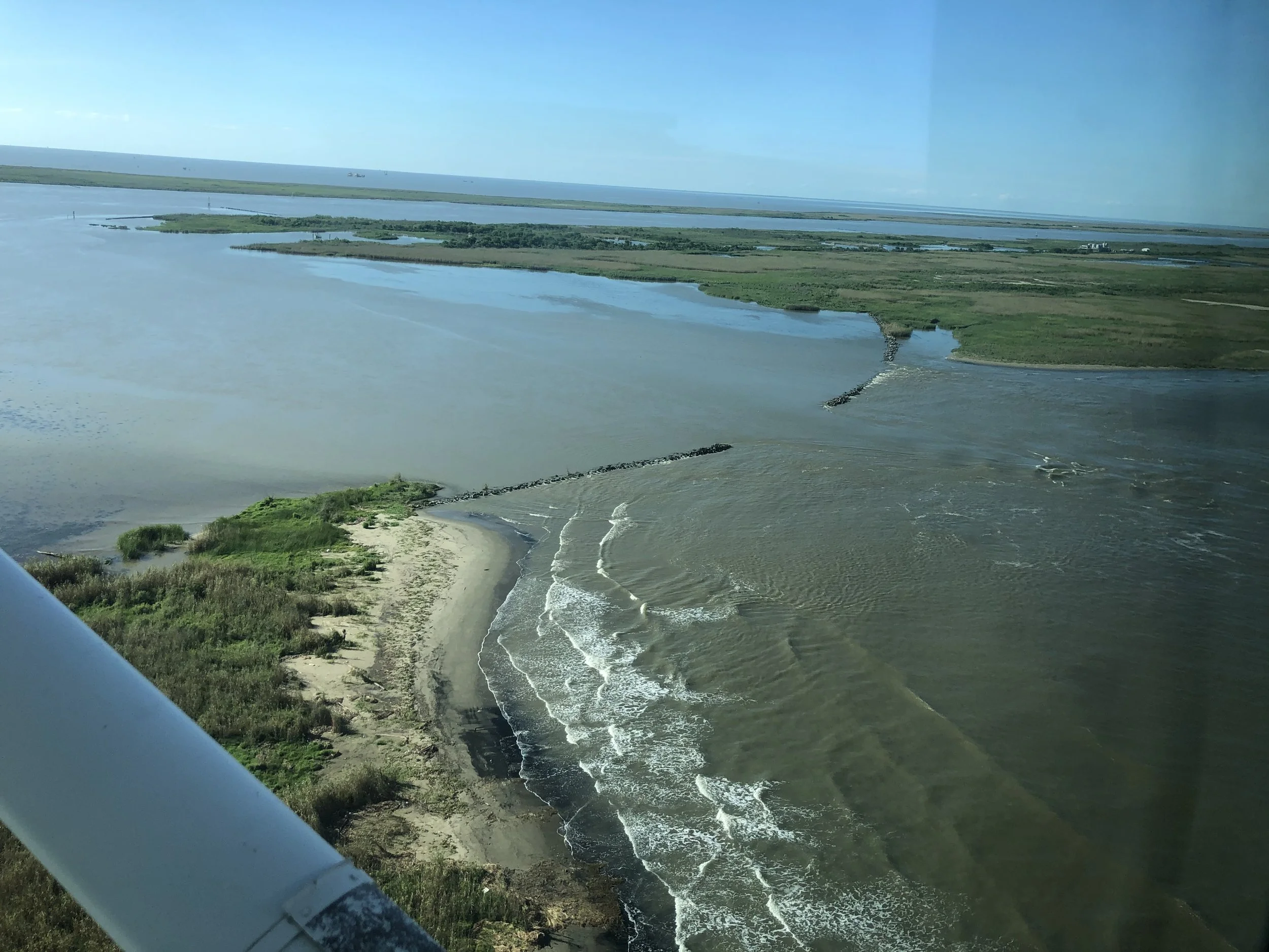
Small boat upbound in Avulsion Pass with a warship in the main channel headed to New Orleans. Photo by James Collier
Avulsion Pass is the newest distributary of the Mississippi River. Beginning as a small unnamed cut near Buras, Louisiana just downstream of the former village of Ostrica, Louisiana on the east bank, this new distributary of the Mississippi River is deep, powerful, and here to stay.
Bound by the laws of physics to get to the sea without delay, the Mississippi River is beginning to shave off 40 miles of river and passes to create a new outlet to the Gulf of Mexico.
Located at 24 miles above Head of Passes, and around 71 miles downstream of the French Quarter, as of this writing in late April 2022, Avulsion Pass is 810’ across and 45’ deep in most places with a sizable canyon carved to -95’ where the cut meets the river. In some places nearer to Quarantine Bay, depths greater than 80’ exist. A former levee was losing around two feet of ground daily while the river was at its peak. While not unprecedented, nothing quite like this has happened this generation in the delta. This new waterway is the avulsion long predicted for the Mississippi River.
Unlike Mardi Gras Pass, with an extensive and complicated pre existing distributary network, Avulsion Pass is a direct shortcut to the Gulf of Mexico. No obstructions currently exist at this location between the Mississippi and the Gulf of Mexico.

Mile Marker 24, twice replaced by the Coast Guard due to erosion and high currents, now stands just downstream of Avulsion Pass. Photo by James Collier
From observing the crevasses’ development over the years it seems that the cut has had three major stages of development so far.
Starting as a small crevasse left unchecked, rock and articulated concrete matting revetments failed under constant flow in a similar process to Niagara Falls’ erosional patterns, but underwater and out of sight. Softer clays and sands under the revetment were displaced over time. This happened on the back side of the revetment, out of the main river channel until sufficient depth was reached for what happened next.
An Island suddenly disappeared over a few weeks. With this bottleneck removed, the capacity to move more water increased significantly. Around this time, in just thirty months or so, the cut grew tremendously in size from the surface perspective.
Today’s condition: Continued capacity building. Avulsion Pass is not finished. With depths as much as 30’ near the banks of Avulsion Pass, the Mighty Mississippi is allowing more water to pass through daily.

A fine balancing act exists to keep commerce moving. Using a jetty concept developed by James Buchanan Eads, a high velocity is needed to keep channels self scouring for navigation requirements. Ships have grown to dizzying proportions and the draft of the channel has been deepened over the years. Still, the concept of self scouring and dredging the leftovers has remained static since the turn of the last century. Humanity is operating the system in perhaps an 1880s way of thinking. Maybe this new development will allow for some 21st century solutions to managing the lower river?
As published in National Geographic in 1897, shortly after the river levees and jetties were built, these enormous economic benefits would come at a cost:
“…No doubt the great benefit to the present and two or three following generations accruing from a complete system of absolutely protective levees… …far outweighs the disadvantages to future generations from the subsidence of the Gulf delta lands below the level of the sea and their gradual abandonment due to this cause. While it would be generally conceded that the present generation should not be selfish, yet it is safe to say that the development of the delta country during the twentieth century by a fully protective levee system, at whatever cost… …will be so remarkable that the people of the whole United States can well afford, when the time comes, to build a protective levee against the Gulf waters.”
Corthell, E. L. “Delta of the Mississippi River.” National Geographic. Dec. 1897: 351-354.
It’s now time to act. A tremendous opportunity is present for nature to be leveraged. In the past, humanity has not been the best at taking care of the delta. The delta has had declining landmass over the last century. Somewhere on the order of 2000 square miles of land have been lost to the gulf due to short sighted management techniques dialed narrowly on certainty of commerce. Avulsion Pass can create a new massive subdelta.
I worry that the Corps gets to work with its business-as-usual way of throwing money and rocks at the new development and misses an opportunity to work with the community on a solution that helps to establish a new delta in the area. This would be less expensive and have greater success. Cubits Gap, The Venice Jump, Garden Island Bay, are all places that have big sub-deltas built since european arrival. That massive land growth can be replicated at Avulsion Pass.

Wells et al., 1983
Innovative ideas like using the intersection of Avulsion Pass and the Mississippi River as a new hopper dredge disposal area would save the Corps money and take sediment out of the system before it must be handled again in the Bird’s Foot Delta. We need not have limits on our imagination when thinking about how to keep the main trunk of the river in place for certainty of navigation and wetland creation. Those two goals should be of equal importance. In an age where cumulative environmental degradation is impacting our lives and commerce, opportunities to harness Avulsion Pass must be taken. This will require the Corps to be quick on their feet, can they rise to the occasion? Or will Avulsion Pass be the undoing of one of the world’s great deltas?
Rock repair at a new cut along Southwest Pass. This concept, but using sediment three miles out where the flow is greatly reduced could help to usher a new delta into existence.
The last time something like this happened it was caught relatively quickly as it was just a few miles from the Southwest Pass pilot station. An arc of rock had to be placed on the backside of a new cut as the water was too deep and swift at the river. Lessons can be taken from that action. Instead of rock, humanity can use sediment to build mouth bars, urging along the development of a new delta. Those actions would slow the flow of water in a similar manner to natural delta formation pairing experts in fluvial geomorphology and local expertise. Avulsion Pass is too deep and too swift for any economical repairs where it meets the river. Even if rock repairs were attempted it would need to be quite far from where the pass enters into Quarantine Bay, possibly 500 yards into the bay at minimum.
One thing is certain, at this point solutions will need to be grand. Humanity and the federal government can throw two thousand barge loads of rock the size of Volkswagens into this hole in the river - an underwater rockpile that will require half a mountain of material that only serves one purpose, or we can take our collective breath and develop a solution between community and government that guides nature to build a grand subdelta while keeping shipping moving. Truth be told, it may be the only thing that we can do within reason.
-Richie